Decoding the Green: Understanding the USDA plant Hardiness Zone Map for the USA
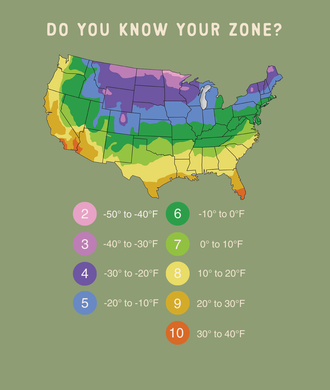
The United States, a land of vast geographical diversity, presents a kaleidoscope of climates, from the frigid Alaskan tundra to the sun-drenched deserts of Arizona. This climatic tapestry profoundly influences which plants can thrive in different regions. To navigate this complexity, the United States Department of Agriculture (USDA) developed the Plant Hardiness Zone Map, a crucial tool for gardeners, landscapers, and farmers alike. This map divides the country into zones based on average annual extreme minimum winter temperatures, providing a vital guide for selecting plants that can withstand local conditions.
The USDA Plant Hardiness Zone Map, originally created in 1960 and updated periodically, is a visual representation of these zones. It divides the United States into 13 primary zones, each further subdivided into “a” and “b” sections. Each zone represents a 10-degree Fahrenheit difference in the average annual extreme minimum winter temperature, with the “a” and “b” subdivisions representing 5-degree differences.

Zone 1: The coldest zone, primarily found in Alaska’s interior, experiences average minimum winter temperatures below -60°F.
The zones in between represent a gradual progression of warmer temperatures. For instance, Zone 5 experiences average minimum temperatures between -20°F and -10°F, while Zone 8 experiences temperatures between 10°F and 20°F.
The USDA map is not static. It is regularly updated to reflect changes in climate and to incorporate more accurate data. The most recent update, released in 2023, incorporates data from 1991 to 2020, providing a more current representation of average minimum winter temperatures. The data is collected from thousands of weather stations across the country, ensuring a comprehensive and reliable map.
:max_bytes(150000):strip_icc()/ms-usda-gardening-zone-3a925f9738ce4122b56cde38d3839919.jpg)
The creation of the map involves complex statistical analysis and modeling to interpolate data between weather stations. This process ensures that even areas without direct weather station coverage are assigned an accurate zone.
Understanding your zone is the first step in successful gardening. Here’s how to use the map effectively:
Finding Your Zone
Visit the USDA Plant Hardiness Zone Map website (planthardiness.ars.usda.gov).
Reading Plant Labels
Most plant labels or seed packets will indicate the zones in which the plant thrives.
Considering Microclimates
Your property may have microclimates that differ from the overall zone.
Beyond Minimum Temperatures: Other Factors
The USDA map focuses on minimum winter temperatures, but other factors are crucial for plant survival.
Adapting to Climate Change
Climate change is causing shifts in temperature patterns, potentially altering plant hardiness zones.
The vastness of the United States means a wide range of zones and corresponding plant life. Here’s a brief overview of some key regions:
Northeastern United States (Zones 3-6)
This region experiences cold winters and warm summers.
Southeastern United States (Zones 7-9)
This region enjoys mild winters and hot, humid summers.
Midwestern United States (Zones 3-6)
This region experiences wide temperature fluctuations, with cold winters and hot summers.
Western United States (Zones 4-10)
This region encompasses a wide range of climates, from coastal temperate to arid desert.
Pacific Northwest (Zones 6-9)
This region is known for it’s mild wet winters and dry summers.
Southwest United States (Zones 7-10)
This region is known for its arid climate, and high summer temperatures.
The USDA Plant Hardiness Zone Map is a valuable tool, but it’s essential to supplement it with other resources:
Local Extension Offices
County extension offices provide localized gardening advice and resources.
Gardening Books and Websites
Numerous books and websites offer detailed information on plant selection and care.
Local Nurseries and Garden Centers
Local nurseries and garden centers can provide expert advice on plant selection and care.
Experienced Gardeners
As climate patterns continue to evolve, gardeners must adapt their practices and embrace sustainable gardening techniques. This includes:
Water Conservation
Soil Health
Native Plants
Pollinator Gardens
Sustainable Landscaping
The USDA Plant Hardiness Zone Map remains a cornerstone of gardening in the United States. By understanding its principles and supplementing it with local knowledge, gardeners can create thriving landscapes that adapt to the ever-changing environment.


