Navigating the Verdant Tapestry: Understanding plant Zones Across the USA
The United States, a land of staggering geographic diversity, boasts a climate mosaic as varied as its landscapes. From the sweltering deserts of the Southwest to the frigid tundras of Alaska, the ability to cultivate thriving gardens and landscapes hinges on understanding the concept of plant hardiness zones. These zones, meticulously mapped and refined, provide a crucial framework for gardeners, farmers, and landscape architects seeking to select plants that will flourish in their specific locales.
This article delves into the intricacies of plant zones across the USA, exploring their origins, applications, and the dynamic factors that influence their relevance.
:max_bytes(150000):strip_icc()/ms-usda-gardening-zone-3a925f9738ce4122b56cde38d3839919.jpg)
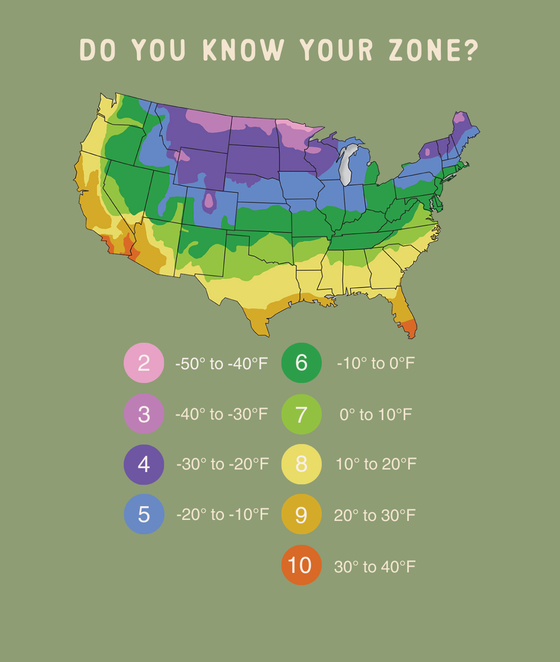
The United States Department of Agriculture (USDA) Plant Hardiness Zone Map is the cornerstone of horticultural planning in the country. It divides the nation into 13 zones, each representing a 10°F (5.6°C) difference in the average annual extreme minimum winter temperature. These zones are further subdivided into “a” and “b” sections, each representing a 5°F (2.8°C) difference, offering even greater precision.
Understanding the Zone Numbers
Zone 1: Represents the coldest regions, primarily in Alaska, with average minimum winter temperatures below -60°F (-51.1°C).

How the Zones Are Determined
The USDA zone map is based on 30-year averages of the lowest annual winter temperatures. This data, collected from weather stations across the country, provides a reliable estimate of the cold tolerance required for plants to survive winter conditions. However, it’s crucial to remember that these are averages, and individual years can deviate significantly.
The Importance of Zone Information
Plant Selection: The primary purpose of plant zones is to guide plant selection. Nurseries and seed catalogs often specify the zones in which a particular plant is likely to thrive.
The USA’s vastness creates a patchwork of microclimates within each zone, adding complexity to gardening practices.
The Northeast: A Region of Seasonal Extremes
The Northeast, encompassing zones 3 through 7, experiences significant seasonal temperature fluctuations. Winters are cold and snowy, while summers can be hot and humid.
Zone 3: Northern Maine and parts of the Adirondacks experience harsh winters, requiring hardy evergreens and cold-tolerant perennials.
The Southeast: A Land of Warmth and Humidity
The Southeast, encompassing zones 7 through 10, is characterized by hot summers and mild winters. High humidity is a defining feature.
Zone 7 and 8: The upper South experiences moderate winters, allowing for the cultivation of camellias, azaleas, and other flowering shrubs.
The Midwest: A Heartland of Diverse Climates
The Midwest, spanning zones 3 through 6, experiences a wide range of temperatures, from frigid winters to hot summers.
Zone 3 and 4: The northern Midwest experiences harsh winters, requiring hardy prairie grasses and cold-tolerant trees.
The Southwest: A Region of Aridity and Extremes
The Southwest, encompassing zones 4 through 10, is characterized by arid conditions and extreme temperature fluctuations.
Zone 4 and 5: Higher elevations in the Rockies experience cold winters, requiring drought-tolerant conifers and alpine plants.
The Pacific Northwest: A Coastal Climate of Mildness and Moisture
The Pacific Northwest, encompassing zones 4 through 9, is characterized by mild, wet winters and cool, dry summers.
Zone 4 through 6: Higher elevations in the Cascades experience colder winters, requiring hardy conifers and alpine plants.
Alaska and Hawaii: Unique Climatic Zones
Alaska and Hawaii present unique challenges and opportunities for gardening.
Alaska: Spanning zones 1 through 8, Alaska experiences a wide range of climates, from Arctic tundra to coastal rainforest. Short growing seasons and extreme cold are major challenges.
While the USDA zone map provides a valuable framework, it’s essential to consider local factors that can influence plant growth.
Microclimates
Urban Heat Islands: Cities tend to be warmer than surrounding rural areas, creating localized microclimates.
Soil Conditions
Soil Type: Sandy, clay, and loam soils have different drainage and nutrient-holding capacities, influencing plant growth.
Other Considerations
Sun Exposure: Plants have varying requirements for sunlight, from full sun to shade.
Climate change is causing shifts in temperature patterns, leading to changes in plant hardiness zones. Some areas are experiencing warmer winters, allowing for the cultivation of plants previously considered tender. It is important to keep up to date with the newest USDA plant hardiness zone maps, as they are updated periodically.
Adapting to Change
Monitoring Local Conditions: Pay attention to local weather patterns and adjust gardening practices accordingly.
The USDA Plant Hardiness Zone Map is an indispensable tool for gardeners and landscape professionals across the USA. However, it’s crucial to remember that it’s just one piece of the puzzle. By understanding the complexities of regional climates, microclimates, and local conditions, and by staying aware of the impacts of climate change, individuals can cultivate thriving gardens and landscapes that enhance the beauty and sustainability of their communities. The journey of gardening is a constant learning process, and the ability to adapt and learn from the natural world is the key to success.
:max_bytes(150000):strip_icc()/ms-usda-gardening-zone-3a925f9738ce4122b56cde38d3839919.jpg?ssl=1)


